LATEST TRACKING PROJECTIONS OF TROPICAL STORM FRANKLIN
The National Hurricane Center is issuing advisories on Tropical
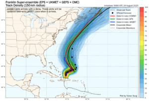
Storm Franklin, located inland over the Dominican Republic. The
Weather Prediction Center has issued the final advisory on
Post-Tropical Cyclone Harold, located inland over northern Mexico.
A Flood Watch is in effect across portions of the Trans-Pecos and
Big Bend regions of Texas. A small Flood Watch is in effect in the
vicinity of Ruidoso, New Mexico.

Interests in Southwestern U.S. and northern Mexico should continue
to monitor the progress of this system.
The remnants are moving
toward the northwest near 24 mph (39 km/h) and this motion is
expected to continue today.
Maximum sustained winds are near 25 mph (35 km/h) with higher gusts.
Harold is expected to produce additional rainfall amounts
of 1 to 2 inches with isolated storm totals of 4 inches across Trans
Pecos region of Texas today, mainly west of the Big Bend. Isolated
to widely scattered instances of flash flooding are possible.

In far northern Mexico, rainfall amounts of 1 to 2 inches with local
amounts of 4 inches are expected through today across northern
portions of Chihuahua. Isolated instances of flash flooding are
expected with landslides possible.

Winds could be particularly gusty in and near areas of
elevated terrain across far northern Mexico and west Texas through
Wednesday. Higher gusts could persist even after the surface system
dissipates.
For storm information specific to your area, including possible inlandwatches and warnings, please monitor products issued by your local National Weather Service forecast office.
Central Subtropical Atlantic (Remnants of Emily): An area of low pressuremore than 1000 miles miles northeast of the Leeward Islands continues to produce a large area of disorganized showers and thunderstorms northeast ofits center. Upper-level winds are forecast to become more conducive for development by tomorrow, and this system is likely to regenerate into a tropical depression or tropical storm late this week or this weekend whenthe system moves northward over the subtropical central Atlantic. Disorganizedshowers and thunderstorms continue in association with an area of low pressurelocated several hundred miles west of the Cabo Verde Islands. Environmentalconditions appear only marginally favorable for some slow development throughearly next week while the system moves west-northwestward to northwestwardinto the central tropical Atlantic. An elongated area of showers and thunderstormslocated several hundred miles south of the coast of southern Mexico is associatedwith a trough of low pressure. Environmental conditions appear favorable forgradual development of this system, and a tropical depression is likely to formwithin the next two to three days while it moves slowly to the northwest ornorth-northwest. An area of low pressure could form well south-southwest of thesouthern tip of the Baja California Peninsula within the next day or two.Environmental conditions are expected to be conducive for some gradual developmentof this system later this week and this weekend while it moves west-northwestwardover the central portion of the tropical eastern Pacific.
Information on Post-Tropical Cyclone Harold can be found in Public Advisoriesissued by the Weather Prediction Center, under AWIPS header TCPAT4, WMO header WTNT34 KWNH, and on the web at www.hurricanes.gov. High Seas Forecasts issuedby the National Weather Service can be found under AWIPS header NFDHSFAT1, WMOheader FZNT01 KWBC, and online at ocean.weather.gov/shtml/NFDHSFAT1.php
To provide the best experiences, we use technologies like cookies to store and/or access device information. Consenting to these technologies will allow us to process data such as browsing behavior or unique IDs on this site. Not consenting or withdrawing consent, may adversely affect certain features and functions.
Functional
Always active
The technical storage or access is strictly necessary for the legitimate purpose of enabling the use of a specific service explicitly requested by the subscriber or user, or for the sole purpose of carrying out the transmission of a communication over an electronic communications network.
Preferences
The technical storage or access is necessary for the legitimate purpose of storing preferences that are not requested by the subscriber or user.
Statistics
The technical storage or access that is used exclusively for statistical purposes.The technical storage or access that is used exclusively for anonymous statistical purposes. Without a subpoena, voluntary compliance on the part of your Internet Service Provider, or additional records from a third party, information stored or retrieved for this purpose alone cannot usually be used to identify you.
Marketing
The technical storage or access is required to create user profiles to send advertising, or to track the user on a website or across several websites for similar marketing purposes.